
Basic Metro Map
Shows all 14 main Metro lines and 2 secondary “bis” lines, RER lines A through E and Trams lines 1, 2 and 3.
Condensed Metro Map
Same as the Basic Metro Map but in a smaller format, good for printing on a 4×6 sheet of photo paper.
Metro Line Map with Streets
Same as above Metro maps but shown in relation to Paris city streets.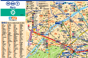
All maps are provided by Paris’ regional public transit authority: RATP.
No comments:
Post a Comment